
Make a donation
Gear up for your next adventure:
As an Amazon Associate, this site earns from qualifying purchases at no extra cost to you.
Sirkka topographic map
Click on the map to display elevation.
Make a donation
Gear up for your next adventure:
As an Amazon Associate, this site earns from qualifying purchases at no extra cost to you.
About this map
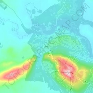
Name: Sirkka topographic map, elevation, terrain.
Average elevation: 230 m
Minimum elevation: 178 m
Maximum elevation: 528 m
Make a donation
Gear up for your next adventure:
As an Amazon Associate, this site earns from qualifying purchases at no extra cost to you.
Other topographic maps
Click on a map to view its topography, its elevation and its terrain.
Make a donation
Gear up for your next adventure:
As an Amazon Associate, this site earns from qualifying purchases at no extra cost to you.
Make a donation
Gear up for your next adventure:
As an Amazon Associate, this site earns from qualifying purchases at no extra cost to you.
Kittilä
Kittilä has a subarctic climate (Dfc) as a result of its northerly location and being far inland, which renders strong seasonal shifts. The sun does not set between 30 May and 15 July (47 days), and white nights lasts from early May to early August. The period that the sun does not rise lasts from 14 December…
Average elevation: 254 m
Make a donation
Gear up for your next adventure:
As an Amazon Associate, this site earns from qualifying purchases at no extra cost to you.
Make a donation
Gear up for your next adventure:
As an Amazon Associate, this site earns from qualifying purchases at no extra cost to you.
Utsjoki
The Utsjoki region is flatter and lower in altitudes than many others. Large areas of Utsjoki are less than 300 m above sea level. Many fjell summits are less than 500 m high. In general, the topography is smooth and the fjells slope gently. The summits are very flat and large in area as is typical of old…
Average elevation: 291 m
Make a donation
Gear up for your next adventure:
As an Amazon Associate, this site earns from qualifying purchases at no extra cost to you.