
Make a donation
Gear up for your next adventure:
As an Amazon Associate, this site earns from qualifying purchases at no extra cost to you.
West topographic map
Click on the map to display elevation.
Make a donation
Gear up for your next adventure:
As an Amazon Associate, this site earns from qualifying purchases at no extra cost to you.
About this map
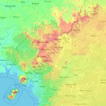
Name: West topographic map, elevation, terrain.
Location: West, Cameroon (2.92112 8.05287 8.12112 13.25287)
Average elevation: 529 m
Minimum elevation: -1 m
Maximum elevation: 3,977 m
Make a donation
Gear up for your next adventure:
As an Amazon Associate, this site earns from qualifying purchases at no extra cost to you.
Other topographic maps
Click on a map to view its topography, its elevation and its terrain.
Make a donation
Gear up for your next adventure:
As an Amazon Associate, this site earns from qualifying purchases at no extra cost to you.
North
The Bénoué Depression constitutes the North Province's primary land feature. This basin runs along the Mayo Kébi and Bénoué River and has an elevation of between zero and 200 metres. The valleys surrounding the various rivers that feed the Kébi and later Bénoué reach elevations only slightly higher…
Average elevation: 554 m
Make a donation
Gear up for your next adventure:
As an Amazon Associate, this site earns from qualifying purchases at no extra cost to you.
Yaoundé
Yaoundé (UK: /jɑːˈʊndeɪ, -ˈuːn-/; US: /ˌjɑːʊnˈdeɪ/, French pronunciation: [ja.unde]) is the capital of Cameroon and, with a population of more than 2.8 million, the second-largest city in the country after the port city Douala. It lies in the Centre Region of the nation at an elevation of…
Average elevation: 724 m
Make a donation
Gear up for your next adventure:
As an Amazon Associate, this site earns from qualifying purchases at no extra cost to you.