
Lambayeque topographic map
Interactive map
Click on the map to display elevation.
About this map
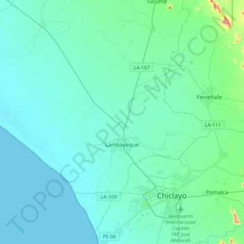
Name: Lambayeque topographic map, elevation, terrain.
Location: Lambayeque, Pérou (-6.75543 -80.11175 -6.58963 -79.78143)
Average elevation: 24 m
Minimum elevation: 0 m
Maximum elevation: 241 m
Other topographic maps
Click on a map to view its topography, its elevation and its terrain.
El Medano
Pérou > Lambayeque > Olmos > El Medano
El Medano, Olmos, Lambayeque, Pérou
Average elevation: 155 m
Chongoyape
Pérou > Lambayeque > Chongoyape
Chongoyape, Chiclayo, Lambayeque, Pérou
Average elevation: 574 m
José Leonardo Ortiz
Pérou > Lambayeque > José Leonardo Ortiz
José Leonardo Ortiz, Chiclayo, Lambayeque, 14013, Pérou
Average elevation: 30 m