
Make a donation
Gear up for your next adventure:
As an Amazon Associate, this site earns from qualifying purchases at no extra cost to you.
Hythe End topographic map
Click on the map to display elevation.
Make a donation
Gear up for your next adventure:
As an Amazon Associate, this site earns from qualifying purchases at no extra cost to you.
About this map
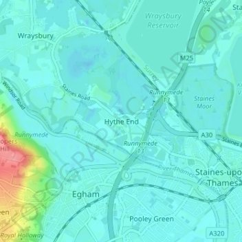
Name: Hythe End topographic map, elevation, terrain.
Average elevation: 21 m
Minimum elevation: 10 m
Maximum elevation: 88 m
Make a donation
Gear up for your next adventure:
As an Amazon Associate, this site earns from qualifying purchases at no extra cost to you.
Other topographic maps
Click on a map to view its topography, its elevation and its terrain.
Formosa Island
United Kingdom > England > Royal Borough of Windsor and Maidenhead > Cookham
Average elevation: 48 m
Windsor Castle
United Kingdom > England > Royal Borough of Windsor and Maidenhead > Windsor > Clewer Village
Average elevation: 23 m
Make a donation
Gear up for your next adventure:
As an Amazon Associate, this site earns from qualifying purchases at no extra cost to you.
Cox Green
United Kingdom > England > Royal Borough of Windsor and Maidenhead > Maidenhead
Average elevation: 36 m
Windsor Marina
United Kingdom > England > Royal Borough of Windsor and Maidenhead > Oakley Green
Average elevation: 26 m
Wraysbury
United Kingdom > England > Royal Borough of Windsor and Maidenhead
The new chapel, with its elegant slender tower, was opened on 16 October 1862; the building works had cost around £800. The striking terracotta relief panel, The City of Refuge, on the front elevation of the chapel, was created by the renowned Doulton & Co artist George Tinworth and is signed with his…
Average elevation: 26 m
Make a donation
Gear up for your next adventure:
As an Amazon Associate, this site earns from qualifying purchases at no extra cost to you.
White Waltham
United Kingdom > England > Royal Borough of Windsor and Maidenhead
Average elevation: 41 m
Shottesbrooke
United Kingdom > England > Royal Borough of Windsor and Maidenhead
Average elevation: 41 m
Magna Carta Island
United Kingdom > England > Royal Borough of Windsor and Maidenhead > Wraysbury
Average elevation: 32 m
Old Windsor
United Kingdom > England > Royal Borough of Windsor and Maidenhead
Average elevation: 38 m
Make a donation
Gear up for your next adventure:
As an Amazon Associate, this site earns from qualifying purchases at no extra cost to you.
Bridge Gardens
United Kingdom > England > Royal Borough of Windsor and Maidenhead > Maidenhead
Average elevation: 30 m
Upton Court Park
United Kingdom > England > Royal Borough of Windsor and Maidenhead > Slough
Average elevation: 23 m
Windsor Castle
United Kingdom > England > Royal Borough of Windsor and Maidenhead > Windsor > Clewer Village
Average elevation: 23 m
Make a donation
Gear up for your next adventure:
As an Amazon Associate, this site earns from qualifying purchases at no extra cost to you.
Windsor Castle
United Kingdom > England > Royal Borough of Windsor and Maidenhead > Windsor > Clewer Village
Average elevation: 23 m
Windsor Castle
United Kingdom > England > Royal Borough of Windsor and Maidenhead > Windsor > Clewer Village
Average elevation: 23 m
Sunningdale
United Kingdom > England > Royal Borough of Windsor and Maidenhead
Average elevation: 61 m
Make a donation
Gear up for your next adventure:
As an Amazon Associate, this site earns from qualifying purchases at no extra cost to you.
Wraysbury
United Kingdom > England > Royal Borough of Windsor and Maidenhead
The new chapel, with its elegant slender tower, was opened on 16 October 1862; the building works had cost around £800. The striking terracotta relief panel, The City of Refuge, on the front elevation of the chapel, was created by the renowned Doulton & Co artist George Tinworth and is signed with his…
Average elevation: 25 m
Sunningdale
United Kingdom > England > Royal Borough of Windsor and Maidenhead
Average elevation: 61 m
Make a donation
Gear up for your next adventure:
As an Amazon Associate, this site earns from qualifying purchases at no extra cost to you.
Waltham St. Lawrence
United Kingdom > England > Royal Borough of Windsor and Maidenhead
Average elevation: 44 m
Horton
United Kingdom > England > Royal Borough of Windsor and Maidenhead > Horton
Average elevation: 18 m
Make a donation
Gear up for your next adventure:
As an Amazon Associate, this site earns from qualifying purchases at no extra cost to you.