
Lamuño topographic map
Interactive map
Click on the map to display elevation.
About this map
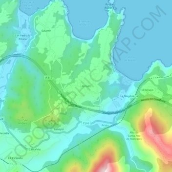
Name: Lamuño topographic map, elevation, terrain.
Location: Lamuño, Cudillero, Asturias, 33155, España (43.54142 -6.22077 43.58142 -6.18077)
Average elevation: 93 m
Minimum elevation: -1 m
Maximum elevation: 437 m
Se encuentra a una altitud de 117 m s. n. m., pero prácticamente en primera línea de mar, en lo alto de un acantilado, pero está a unos 5 minutos de las playas de San Pedro, Oleiro y Concha de Artedo. La distancia a Cudillero es de 9 km.
Other topographic maps
Click on a map to view its topography, its elevation and its terrain.