
Federation of Bosnia and Herzegovina topographic map
Interactive map
Click on the map to display elevation.
About this map
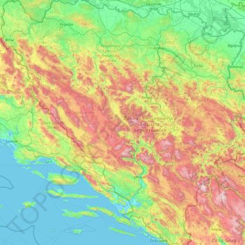
Name: Federation of Bosnia and Herzegovina topographic map, elevation, terrain.
Location: Federation of Bosnia and Herzegovina, Bosnia and Herzegovina (42.60263 15.72874 45.23111 19.04991)
Average elevation: 557 m
Minimum elevation: -3 m
Maximum elevation: 2,380 m
Other topographic maps
Click on a map to view its topography, its elevation and its terrain.
Dinaric Alps
Bosnia and Herzegovina > Federation of Bosnia and Herzegovina > City of Livno
Average elevation: 1,599 m
Race
Bosnia and Herzegovina > Federation of Bosnia and Herzegovina > Resanovci
Average elevation: 904 m
Stranjani
Bosnia and Herzegovina > Federation of Bosnia and Herzegovina > City of Zenica
Average elevation: 648 m
Visoko
Bosnia and Herzegovina > Federation of Bosnia and Herzegovina > Grad Visoko
The Visoko municipality covers 232 square kilometres with several characteristic, morphologically distinctive valleys formed by the foothills of the Central Bosnian mountains including Ozren, Vranica and Zvijezda. The altitude of the region ranges from 400 to 1,050 metres. Visoko's natural environment is…
Average elevation: 527 m
Jablanica
Bosnia and Herzegovina > Federation of Bosnia and Herzegovina > Jablanica
Average elevation: 468 m
Međugorje
Bosnia and Herzegovina > Federation of Bosnia and Herzegovina > Međugorje
Average elevation: 211 m
Čapljina
Bosnia and Herzegovina > Federation of Bosnia and Herzegovina > Čapljina
Average elevation: 98 m
Mostar
Bosnia and Herzegovina > Federation of Bosnia and Herzegovina > Mostar
Average elevation: 599 m
Zenica
Bosnia and Herzegovina > Federation of Bosnia and Herzegovina > City of Zenica
The city is geographically located in the heart of Bosnia. The settled area is 43.01 km2 (16.61 sq mi) and of the city proper covers 558.5 km2 (215.6 sq mi). Elevation is 310–350 m (1,017–1,148 ft). The rivers Bosna, Lašva, Babina, and Kočeva flow through the settlement. A moderate continental climate…
Average elevation: 730 m