Geolocate

Storrington topographic map

Click on the map to display elevation.

About this map
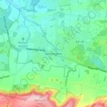
Name: Storrington topographic map, elevation, terrain.

Location: Storrington, Horsham, West Sussex, England, RH20 4EE, United Kingdom (50.89845 -0.47555 50.93845 -0.43555)

Average elevation: 60 m

Minimum elevation: 6 m

Maximum elevation: 209 m

Other topographic maps

Click on a map to view its topography, its elevation and its terrain.
Amberley

United Kingdom > England > West Sussex > Horsham

Average elevation: 37 m

Rusper

United Kingdom > England > West Sussex > Horsham

Average elevation: 86 m

Gear up for your next adventure:

🕯️Emergency Whistles - Safety whistles for hiking
🩹Wilderness First Aid Kits - Comprehensive medical kits tailored for hiking and remote exploration
📍Handheld GPS - GPS devices for hiking and navigation
🔪Outdoor Multi-tools - Versatile tools for gear repair and survival tasks in the wilderness
🧤Thermal Hiking Gloves - Keep your hands warm and functional during high-altitude winter treks

As an Amazon Associate, this site earns from qualifying purchases at no extra cost to you.