
Kashiwa topographic map
Interactive map
Click on the map to display elevation.
Kashiwa
Kashiwa is located on the Shimōsa Plateau in the far northwestern corner of Chiba Prefecture, about 30 kilometers from the prefectural capital at Chiba and 25 to 35 kilometers from central Tokyo. It is separated from Ibaraki Prefecture to the north by the Tone River. Located on the Kanto Plain, the city is flat, with an elevation of between 5 and 32 meters above sea level.
About this map
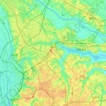
Name: Kashiwa topographic map, elevation, terrain.
Location: Kashiwa, Chiba Prefecture, Japan (35.78122 139.91332 35.93585 140.11194)
Average elevation: 17 m
Minimum elevation: -6 m
Maximum elevation: 40 m
Other topographic maps
Click on a map to view its topography, its elevation and its terrain.
東京湾
The shoal between Cape Futtsu in Chiba Prefecture and Cape Honmaku in Yokohama is known as Nakanose, and has a depth of 20 metres (66 ft). North of this area the bay has a depth of 40 metres (130 ft) and an uncomplicated underwater topography. Areas south of Nakanose are significantly deeper moving towards the…
Average elevation: 0 m