
Jjemba West topographic map
Interactive map
Click on the map to display elevation.
About this map
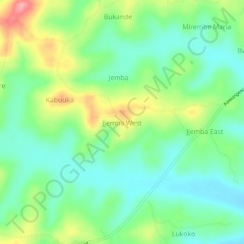
Name: Jjemba West topographic map, elevation, terrain.
Location: Jjemba West, Kassanda, Central Region, Uganda (0.50590 31.76391 0.54590 31.80391)
Average elevation: 1,232 m
Minimum elevation: 1,192 m
Maximum elevation: 1,311 m
Other topographic maps
Click on a map to view its topography, its elevation and its terrain.