
Make a donation
Gear up for your next adventure:
As an Amazon Associate, this site earns from qualifying purchases at no extra cost to you.
Agoura Hills topographic map
Click on the map to display elevation.
Make a donation
Gear up for your next adventure:
As an Amazon Associate, this site earns from qualifying purchases at no extra cost to you.
Agoura Hills
Agoura Hills has a mountain called Ballard Mountain named after pioneer settler and freed slave John Ballard. The name of the mountain was officially changed from Negrohead to Ballard in a ceremony on February 20, 2010. Ladyface Mountain is another prominent mountain on the west side of the Conejo Valley and stands at an elevation of 2,031 feet (619 m).
Make a donation
Gear up for your next adventure:
As an Amazon Associate, this site earns from qualifying purchases at no extra cost to you.
About this map
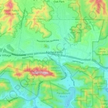
Name: Agoura Hills topographic map, elevation, terrain.
Average elevation: 332 m
Minimum elevation: 225 m
Maximum elevation: 602 m
Make a donation
Gear up for your next adventure:
As an Amazon Associate, this site earns from qualifying purchases at no extra cost to you.
Other topographic maps
Click on a map to view its topography, its elevation and its terrain.
Make a donation
Gear up for your next adventure:
As an Amazon Associate, this site earns from qualifying purchases at no extra cost to you.