
Ebenung topographic map
Interactive map
Click on the map to display elevation.
About this map
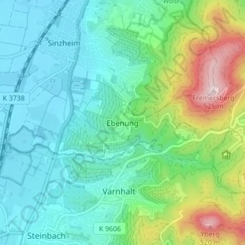
Name: Ebenung topographic map, elevation, terrain.
Average elevation: 223 m
Minimum elevation: 123 m
Maximum elevation: 523 m
Other topographic maps
Click on a map to view its topography, its elevation and its terrain.
Langenbrand
Allemagne > Bade-Wurtemberg > Landkreis Rastatt
Langenbrand, Forbach, Landkreis Rastatt, Bade-Wurtemberg, 76596, Allemagne
Average elevation: 460 m
Bühlertal
Allemagne > Bade-Wurtemberg > Landkreis Rastatt
Bühlertal, Landkreis Rastatt, Bade-Wurtemberg, 77830, Allemagne
Average elevation: 462 m