
Bühlertal topographic map
Interactive map
Click on the map to display elevation.
About this map
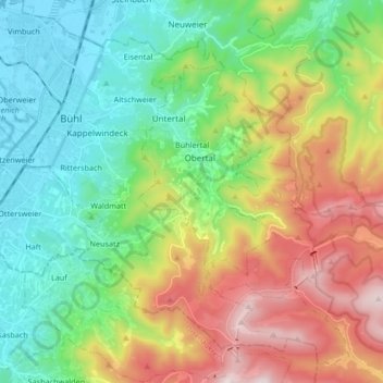
Name: Bühlertal topographic map, elevation, terrain.
Location: Bühlertal, Landkreis Rastatt, Bade-Wurtemberg, 77830, Allemagne (48.63647 8.08161 48.70998 8.24869)
Average elevation: 462 m
Minimum elevation: 126 m
Maximum elevation: 1,082 m
Bühlertal se situe au débouché d'une vallée descendant de la Forêt-Noire. Le territoire de la commune s'étage entre 190 et 1 000 m d'altitude, l'essentiel de l'habitat étant concentré en léger surplomb du Fossé rhénan, dont l'altitude moyenne est à cet endroit d'environ 130 m.
Other topographic maps
Click on a map to view its topography, its elevation and its terrain.
Langenbrand
Allemagne > Bade-Wurtemberg > Landkreis Rastatt
Langenbrand, Forbach, Landkreis Rastatt, Bade-Wurtemberg, 76596, Allemagne
Average elevation: 460 m
Ebenung
Allemagne > Bade-Wurtemberg > Landkreis Rastatt
Ebenung, Sinzheim, Vereinbarte Verwaltungsgemeinschaft Sinzheim, Landkreis Rastatt, Bade-Wurtemberg, 76547, Allemagne
Average elevation: 223 m