
Bucksport topographic map
Interactive map
Click on the map to display elevation.
About this map
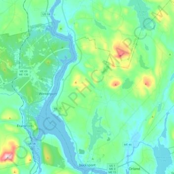
Name: Bucksport topographic map, elevation, terrain.
Location: Bucksport, Hancock County, Maine, 04416, United States (44.56547 -68.84753 44.72171 -68.63794)
Average elevation: 61 m
Minimum elevation: -6 m
Maximum elevation: 317 m
Other topographic maps
Click on a map to view its topography, its elevation and its terrain.
Bar Harbor
United States > Maine > Hancock County
Bar Harbor, Hancock County, Maine, 04609, United States
Average elevation: 33 m
Mount Desert
United States > Maine > Hancock County
Mount Desert, Hancock County, Maine, United States
Average elevation: 31 m
Carney Island
United States > Maine > Hancock County > Deer Isle
Carney Island, Deer Isle, Hancock County, Maine, United States
Average elevation: 7 m
Dog Island
United States > Maine > Hancock County > Swan's Island > Minturn
Dog Island, Minturn, Swan's Island, Hancock County, Maine, United States
Average elevation: 12 m
The Head
United States > Maine > Hancock County > Deer Isle
The Head, Deer Isle, Hancock County, Maine, United States
Average elevation: 2 m