
Cambria County topographic map
Click on the map to display elevation.
About this map
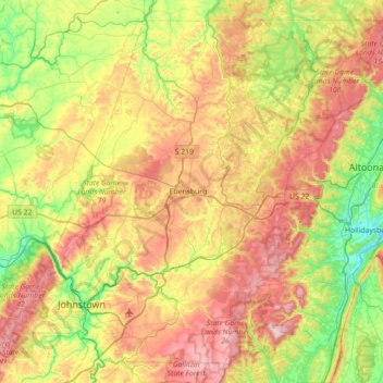
Name: Cambria County topographic map, elevation, terrain.
Location: Cambria County, Pennsylvania, United States (40.24258 -79.05598 40.72604 -78.34839)
Average elevation: 554 m
Minimum elevation: 284 m
Maximum elevation: 956 m
Other topographic maps
Click on a map to view its topography, its elevation and its terrain.
Mill Run
United States > Pennsylvania > Blair County > Altoona > Allegheny Furnace
Average elevation: 349 m
Hubbard Mountain
United States > Pennsylvania > Lackawanna County > Scott Township
Average elevation: 503 m
Willow Grove
United States > Pennsylvania > Montgomery County > Upper Moreland Township
Average elevation: 91 m
Oakville
United States > Pennsylvania > Cumberland County > North Newton Township
Average elevation: 180 m
Parkland Heights
United States > Pennsylvania > Bucks County > Middletown Township
Average elevation: 45 m
Sunshine Hill
United States > Pennsylvania > Fayette County > Nicholson Township
Average elevation: 294 m
Millers
United States > Pennsylvania > Northampton County > Plainfield Township
Average elevation: 200 m
Rehrersburg
United States > Pennsylvania > Berks County > Tulpehocken Township
Average elevation: 165 m
Martin's Creek
United States > Pennsylvania > Northampton County > Lower Mount Bethel Township > Martins Creek
Average elevation: 152 m
Williamstown
United States > Pennsylvania > Lehigh County > Washington Township
Average elevation: 178 m
Chadds Ford
United States > Pennsylvania > Delaware County > Chadds Ford Township > Chadds Ford
Average elevation: 86 m
Plain Grove
United States > Pennsylvania > Plain Grove Township > Plain Grove
Average elevation: 360 m
Audubon
United States > Pennsylvania > Montgomery County > Lower Providence Township > Audubon
Average elevation: 55 m
Fairfield Heights
United States > Pennsylvania > Indiana County > Burrell Township
Average elevation: 396 m
Spring Ridge
United States > Pennsylvania > Berks County > Spring Township > Spring Ridge
Average elevation: 98 m
Rocky Valley
United States > Pennsylvania > Bucks County > Springfield Township
Average elevation: 190 m
Gooseberry Hill
United States > Pennsylvania > Sullivan County > Hillsgrove Township
Average elevation: 446 m
Eyer
United States > Pennsylvania > Huntingdon County > Warriors Mark Township > Eyer
Average elevation: 380 m
Bob Case Park
United States > Pennsylvania > Montgomery County > Upper Merion Township > King of Prussia > Sweet Briar
Average elevation: 45 m
Glenrose
United States > Pennsylvania > Chester County > East Fallowfield Township > Glenrose
Average elevation: 154 m
Philadelphia
United States > Pennsylvania > Philadelphia County > Philadelphia
Average elevation: 35 m
Pendle Hill
United States > Pennsylvania > Delaware County > Nether Providence Township
Average elevation: 61 m
Freysville
United States > Pennsylvania > York County > Windsor Township > Freysville
Average elevation: 233 m