
Malolos topographic map
Interactive map
Click on the map to display elevation.
About this map
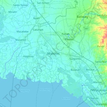
Name: Malolos topographic map, elevation, terrain.
Location: Malolos, Bulacan, Central Luzon, 3000, Philippines (14.68376 120.65137 15.00376 120.97137)
Average elevation: 6 m
Minimum elevation: -3 m
Maximum elevation: 74 m
Malolos is relatively flat of about 0.81% to a gently sloping of 2.17%. The slope of the land descends towards west, southwest to southern direction. The highest land elevation is at about 6.0 meters above sea level while the lowest is only half a meter below sea level. A network of natural waterways and rivers of various sizes and importance is traversing through the landscape of the town down south to Manila Bay.
Other topographic maps
Click on a map to view its topography, its elevation and its terrain.
Longos
Philippines > Bulacan > Malolos
Longos, Malolos, Bulacan, Central Luzon, 3000, Philippines
Average elevation: 4 m
Baliwag
Baliwag, Bulacan, Central Luzon, 3006, Philippines
Average elevation: 16 m
Longos
Philippines > Bulacan > Calumpit > Longos
Longos, Calumpit, Bulacan, Central Luzon, 3001, Philippines
Average elevation: 4 m
Cruz na Daan
Philippines > Bulacan > San Rafael > Cruz na Daan
Cruz na Daan, San Rafael, Bulacan, Central Luzon, 3008, Philippines
Average elevation: 19 m
Deogracias Subdivision
Philippines > Bulacan > Atlag > Deogracias Subdivision
Deogracias Subdivision, Atlag, Bulacan, Central Luzon, 3000, Philippines
Average elevation: 4 m
San Rafael
San Rafael, Bulacan, Central Luzon, 3008, Philippines
Average elevation: 32 m
San Jose del Monte
Philippines > Bulacan > San Jose del Monte
San Jose del Monte, Bulacan, Central Luzon, 3023, Philippines
Average elevation: 106 m
Doña Remedios Trinidad
Philippines > Bulacan > Doña Remedios Trinidad
Doña Remedios Trinidad, Bulacan, Central Luzon, 3009, Philippines
Average elevation: 104 m