Geolocate

Walloon topographic map

Click on the map to display elevation.

About this map

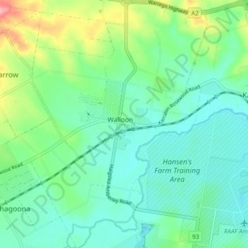
Name: Walloon topographic map, elevation, terrain.

Location: Walloon, Ipswich City, Queensland, Australia (-27.63677 152.63932 -27.57528 152.68886)

Average elevation: 50 m

Minimum elevation: 18 m

Maximum elevation: 143 m

Queensland trails, hiking, mountain biking, running and outdoor activities

Other topographic maps

Click on a map to view its topography, its elevation and its terrain.

Stanton Cross

Australia > Queensland > Ipswich City

Average elevation: 28 m

Mount Grey

Australia > Queensland > Ipswich City

Average elevation: 231 m

Spring Mountain

Australia > Queensland > Ipswich City

Average elevation: 190 m

White Rock

Australia > Queensland > Ipswich City

Average elevation: 114 m

Gear up for your next adventure:

🛌Sleeping Mats - Insulated mats for camping comfort
☀️Portable Solar Chargers - High-efficiency panels to hang on your backpack while walking
🧢Wide Brim Sun Hats - Maximum coverage for the face and neck while out in the open
🎒Hiking Backpacks - Backpacks designed for hiking and trekking
🛰️Handheld GPS Units - Rugged GPS devices for tracking coordinates and elevation in the Australian bush

As an Amazon Associate, this site earns from qualifying purchases at no extra cost to you.