Geolocate

Chitignano topographic map

Click on the map to display elevation.

About this map
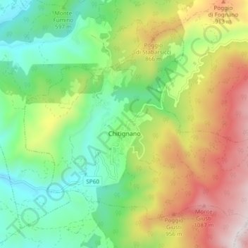
Name: Chitignano topographic map, elevation, terrain.

Location: Chitignano, Arezzo, Tuscany, Italy (43.64373 11.85109 43.68496 11.92553)

Average elevation: 655 m

Minimum elevation: 317 m

Maximum elevation: 1,190 m

Other topographic maps

Click on a map to view its topography, its elevation and its terrain.

Borgo alla Collina

Italy > Tuscany > Arezzo

Average elevation: 436 m

Creti

Italy > Tuscany > Arezzo > Cortona

Average elevation: 260 m

Bellavista

Italy > Tuscany > Arezzo > Ambra

Average elevation: 314 m

Vetrivecchi

Italy > Tuscany > Arezzo > San Giovanni Valdarno

Average elevation: 158 m

Moriello

Italy > Tuscany > Arezzo > Castiglion Fiorentino

Average elevation: 454 m

Upacchi

Italy > Tuscany > Arezzo > Anghiari

Average elevation: 585 m

Toppole

Italy > Tuscany > Arezzo > Anghiari

Average elevation: 509 m

Il Torrino

Italy > Tuscany > Arezzo > Arezzo > Casanuova

Average elevation: 525 m

Duddova

Italy > Tuscany > Arezzo > Bucine

Average elevation: 389 m

Castelluccio

Italy > Tuscany > Arezzo

Average elevation: 260 m

Montagnano

Italy > Tuscany > Arezzo

Average elevation: 257 m

Mengaccini

Italy > Tuscany > Arezzo > Cortona > Mercatale

Average elevation: 412 m

Montalla

Italy > Tuscany > Arezzo > Cortona > Montalla

Average elevation: 326 m

La Villa

Italy > Tuscany > Arezzo > Sansepolcro > La Montagna

Average elevation: 795 m

Gear up for your next adventure:

🧊Insulated Stainless Steel Flasks - Keep water cold for 24 hours in the heat or coffee hot in the cold
📡Portable Emergency Radios - Stay informed about weather warnings and bushfire alerts
🔦Headlamps - Hands-free lighting for hiking
📖Australian Bush Survival Books - Local knowledge on finding water and surviving the outback
👣Snake & Scrub Gaiters - Protection against spinifex, mud, and snakes while walking off-track

As an Amazon Associate, this site earns from qualifying purchases at no extra cost to you.