
Northwood topographic map
Interactive map
Click on the map to display elevation.
About this map
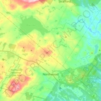
Name: Northwood topographic map, elevation, terrain.
Average elevation: 167 m
Minimum elevation: 68 m
Maximum elevation: 368 m
Other topographic maps
Click on a map to view its topography, its elevation and its terrain.
Jenness Beach
United States > New Hampshire > Rockingham County > Rye > Rye Beach Village District
Jenness Beach, Rye Beach Village District, Rye, Rockingham County, New Hampshire, United States
Average elevation: 5 m
Portsmouth
United States > New Hampshire > Rockingham County
Portsmouth, Rockingham County, New Hampshire, United States
Average elevation: 9 m
Stratham
United States > New Hampshire > Rockingham County
Stratham, Rockingham County, New Hampshire, 03885, United States
Average elevation: 22 m
Newington
United States > New Hampshire > Rockingham County > Newington
Newington, Rockingham County, New Hampshire, 03801-2819, United States
Average elevation: 10 m