
Port Orange topographic map
Interactive map
Click on the map to display elevation.
About this map
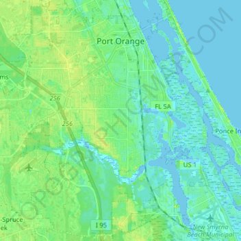
Name: Port Orange topographic map, elevation, terrain.
Location: Port Orange, Volusia County, Florida, United States (29.04473 -81.07241 29.15781 -80.96370)
Average elevation: 6 m
Minimum elevation: -2 m
Maximum elevation: 19 m
Other topographic maps
Click on a map to view its topography, its elevation and its terrain.
Ormond Beach
United States > Florida > Volusia County
Ormond Beach, Volusia County, Florida, United States
Average elevation: 3 m
Daytona Beach
United States > Florida > Volusia County
Daytona Beach, Volusia County, Florida, United States
Average elevation: 5 m
DeLand
United States > Florida > Volusia County
DeLand, Volusia County, Florida, 32723, United States
Average elevation: 20 m
Packwood Place
United States > Florida > Volusia County
Packwood Place, Volusia County, Florida, 32141, United States
Average elevation: 3 m
New Smyrna Beach
United States > Florida > Volusia County
New Smyrna Beach, Volusia County, Florida, United States
Average elevation: 3 m
Edgewater
United States > Florida > Volusia County
Edgewater, Volusia County, Florida, United States
Average elevation: 4 m
Harbor Oaks
United States > Florida > Volusia County > Port Orange
Harbor Oaks, Port Orange, Volusia County, Florida, 32127, United States
Average elevation: 3 m
Halifax Estates
United States > Florida > Volusia County > Daytona Beach Shores
Halifax Estates, Daytona Beach Shores, Volusia County, Florida, 32127, United States
Average elevation: 1 m
Orange City
United States > Florida > Volusia County
Orange City, Volusia County, Florida, 32763, United States
Average elevation: 18 m
Ellinor Village
United States > Florida > Volusia County > Ormond Beach
Ellinor Village, Ormond Beach, Volusia County, Florida, 32117, United States
Average elevation: 3 m
Destination Daytona
United States > Florida > Volusia County
Destination Daytona, Volusia County, Florida, United States
Average elevation: 8 m
Long Island
United States > Florida > Volusia County > New Smyrna Beach
Long Island, New Smyrna Beach, Volusia County, Florida, United States
Average elevation: 7 m
Deltona
United States > Florida > Volusia County
Deltona, Volusia County, Florida, United States
Average elevation: 12 m
Venetian Bay
United States > Florida > Volusia County > New Smyrna Beach
Venetian Bay, New Smyrna Beach, Volusia County, Florida, United States
Average elevation: 8 m
Lorraine Lake
United States > Florida > Volusia County > Deltona
Lorraine Lake, Deltona, Volusia County, Florida, United States
Average elevation: 20 m
Pierson
United States > Florida > Volusia County
Pierson, Volusia County, Florida, 32180, United States
Average elevation: 14 m
Lake Helen
United States > Florida > Volusia County
Lake Helen, Volusia County, Florida, 32744, United States
Average elevation: 21 m
Glencoe
United States > Florida > Volusia County > Glencoe
Glencoe, Volusia County, Florida, 32168, United States
Average elevation: 8 m
Daytona Beach Shores
United States > Florida > Volusia County
Daytona Beach Shores, Volusia County, Florida, United States
Average elevation: 2 m
Daisy Lake
United States > Florida > Volusia County
Daisy Lake, Volusia County, Florida, United States
Average elevation: 6 m
Hammock Field
United States > Florida > Volusia County > Daytona Beach
Hammock Field, Daytona Beach, Volusia County, Florida, 32124, United States
Average elevation: 7 m
Holly Hill
United States > Florida > Volusia County
Holly Hill, Volusia County, Florida, 32117, United States
Average elevation: 4 m
Osteen
United States > Florida > Volusia County
Osteen, Volusia County, Florida, 32764, United States
Average elevation: 12 m
Oak Hill
United States > Florida > Volusia County
Oak Hill, Volusia County, Florida, United States
Average elevation: 3 m
Wilbur-by-the-Sea
United States > Florida > Volusia County > Wilbur-by-the-Sea
Wilbur-by-the-Sea, Volusia County, Florida, 32127, United States
Average elevation: 1 m
Ormond Beach
United States > Florida > Volusia County > Ormond Beach > Ormond Beach
Ormond Beach, Volusia County, Florida, 32176-8105, United States
Average elevation: 4 m
South Daytona
United States > Florida > Volusia County
South Daytona, Volusia County, Florida, United States
Average elevation: 4 m
Enterprise
United States > Florida > Volusia County
Enterprise, Volusia County, Florida, 32728, United States
Average elevation: 7 m
Ortona
United States > Florida > Volusia County > Daytona Beach > Ortona
Ortona, Daytona Beach, Volusia County, Florida, 32117, United States
Average elevation: 3 m
De Leon Springs
United States > Florida > Volusia County
De Leon Springs, Volusia County, Florida, United States
Average elevation: 17 m
Ponce Inlet
United States > Florida > Volusia County
Ponce Inlet, Volusia County, Florida, United States
Average elevation: 1 m
Deltona
United States > Florida > Volusia County > Deltona
Deltona, Volusia County, Florida, 32725, United States
Average elevation: 12 m
De Land Southwest
United States > Florida > Volusia County > De Land Southwest
De Land Southwest, Volusia County, Florida, United States
Average elevation: 20 m
DeBary
United States > Florida > Volusia County
DeBary, Volusia County, Florida, 32713, United States
Average elevation: 10 m