
Florac topographic map
Interactive map
Click on the map to display elevation.
About this map
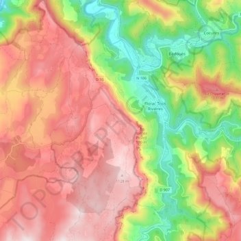
Name: Florac topographic map, elevation, terrain.
Average elevation: 837 m
Minimum elevation: 521 m
Maximum elevation: 1,142 m
L'aérodrome de Florac-Chanet (code ICAO. LFNO) ou de Florac-Sainte-Enimie de son nom officiel, sur la plaine de Chanet, à proximité de Meyrueis, se trouve sur la partie centrale du causse Méjean, à une altitude d'environ 930 m et à 35 km de Florac. C'est une plateforme à usage restreint, qui accueille peu de trafic de l’extérieur. Le club de vol à voile de Chanet y a élu domicile.
Other topographic maps
Click on a map to view its topography, its elevation and its terrain.
Salièges
France > Occitanie > Lozère > Florac Trois Rivières
Salièges, Florac, Florac Trois Rivières, Florac, Lozère, Occitanie, France métropolitaine, 48400, France
Average elevation: 742 m
La Grandville
France > Occitanie > Lozère > Florac Trois Rivières
La Grandville, La Salle-Prunet, Florac Trois Rivières, Florac, Lozère, Occitanie, France métropolitaine, 48400, France
Average elevation: 834 m