
Salièges topographic map
Interactive map
Click on the map to display elevation.
About this map
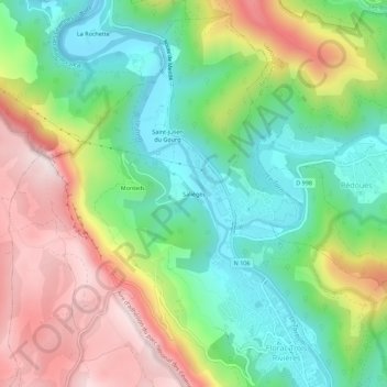
Name: Salièges topographic map, elevation, terrain.
Average elevation: 742 m
Minimum elevation: 518 m
Maximum elevation: 1,067 m
Other topographic maps
Click on a map to view its topography, its elevation and its terrain.
Florac
France > Occitanie > Lozère > Florac Trois Rivières
Florac, Florac Trois Rivières, Florac, Lozère, Occitanie, France métropolitaine, 48400, France
Average elevation: 837 m
La Grandville
France > Occitanie > Lozère > Florac Trois Rivières
La Grandville, La Salle-Prunet, Florac Trois Rivières, Florac, Lozère, Occitanie, France métropolitaine, 48400, France
Average elevation: 834 m