
Salisbury topographic map
Click on the map to display elevation.
About this map
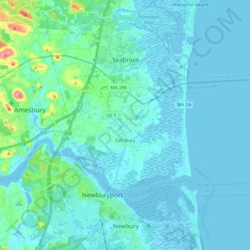
Name: Salisbury topographic map, elevation, terrain.
Location: Salisbury, Essex County, Massachusetts, 01952, United States (42.81298 -70.91463 42.88678 -70.73298)
Average elevation: 11 m
Minimum elevation: -7 m
Maximum elevation: 99 m
Other topographic maps
Click on a map to view its topography, its elevation and its terrain.
Little River Marshes
United States > Massachusetts > Essex County > Gloucester > West Gloucester
Average elevation: 27 m
Freshwater Cove Village
United States > Massachusetts > Essex County > Gloucester
Average elevation: 18 m
Blackwater River
United States > Massachusetts > Essex County > Salisbury > Salisbury Beach
Average elevation: 4 m
Kettle Cove Village
United States > Massachusetts > Essex County > Manchester-by-the-Sea
Average elevation: 18 m
Amesbury
United States > Massachusetts > Essex County > Amesbury
Amesbury is located at 42°51′29″N 70°55′50″W / 42.85806°N 70.93056°W / 42.85806; -70.93056. According to the United States Census Bureau, the city has a total area of 13.7 square miles (35.5 km2), of which 12.3 square miles (31.8 km2) is land and 1.5 square miles (3.8 km2), or 10.65%, is…
Average elevation: 24 m
East Parish
United States > Massachusetts > Essex County > Boxford > Boxford > East Parish
Average elevation: 38 m