
Thrissur topographic map
Interactive map
Click on the map to display elevation.
About this map
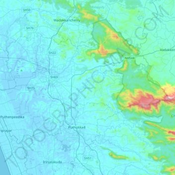
Name: Thrissur topographic map, elevation, terrain.
Location: Thrissur, Thrissur District, Kerala, India (10.38534 76.08338 10.63089 76.47613)
Average elevation: 68 m
Minimum elevation: -6 m
Maximum elevation: 912 m
Other topographic maps
Click on a map to view its topography, its elevation and its terrain.
Adimali
Adimaly generally has a cool climate throughout the year, typical of the higher altitudes, though not as cold as Munnar. Temperatures rarely exceed 26 degrees and never drop below 10 degrees as it usually stays around 17-24 degrees. Though December–January are comparatively cooler than other months. Adimaly…
Average elevation: 786 m
Kothamangalam
India > Kerala > Kothamangalam
Kothamangalam is situated in the eastern part of the Ernakulam district. Kothamangalam is known as the Gateway of Highrange. According to the division of the geographical regions of Kerala, i.e. High-lands, Mid-lands and Low-lands, Kothamangalam is in a Mid-land region. The general topography is hilly. The…
Average elevation: 34 m