Geolocate

Vintrie topographic map

Click on the map to display elevation.

About this map
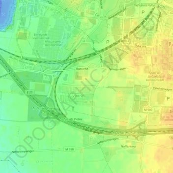
Name: Vintrie topographic map, elevation, terrain.

Location: Vintrie, Väster, Malmo, Malmö kommun, Skåne County, 218 45, Sweden (55.54686 12.93272 55.56219 12.98361)

Average elevation: 15 m

Minimum elevation: -49 m

Maximum elevation: 27 m

Other topographic maps

Click on a map to view its topography, its elevation and its terrain.

Bunkeflo

Sweden > Skåne County > Malmo

Average elevation: 14 m

Jerusalem

Sweden > Skåne County > Malmo

Average elevation: 6 m

Bunkeflo

Sweden > Skåne County > Malmo

Average elevation: 14 m

Arlöv

Sweden > Skåne County > Malmo

Average elevation: 8 m

Helge

Sweden > Skåne County > Malmo

Average elevation: 7 m

Gear up for your next adventure:

🎒Ultralight Backpacks - Lightweight packs for long hikes
🧯Animal Deterrent Spray - Safety spray for wildlife
🔋Solar Power Banks - Charge your phone and GPS using the sun while deep in the bush
🪫Rechargeable Headlamps - USB rechargeable headlamps
🦶Orthotic Hiking Insoles - Extra arch support for long-distance topographic treks

As an Amazon Associate, this site earns from qualifying purchases at no extra cost to you.