
Bous topographic map
Interactive map
Click on the map to display elevation.
About this map
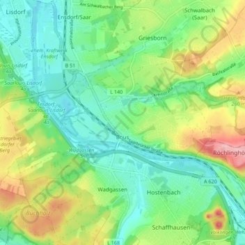
Name: Bous topographic map, elevation, terrain.
Location: Bous, Landkreis Saarlouis, Sarre, 66359, Allemagne (49.26981 6.77470 49.28703 6.85852)
Average elevation: 217 m
Minimum elevation: 173 m
Maximum elevation: 303 m
Other topographic maps
Click on a map to view its topography, its elevation and its terrain.
Réhling-Sierbourg
Allemagne > Sarre > Landkreis Saarlouis > Rehlingen-Siersburg > Réhling-Sierbourg
Réhling-Sierbourg, Rehlingen-Siersburg, Landkreis Saarlouis, Sarre, 66780, Allemagne
Average elevation: 208 m
Réhling-Sierbourg
Allemagne > Sarre > Landkreis Saarlouis
Réhling-Sierbourg, Landkreis Saarlouis, Sarre, 66780, Allemagne
Average elevation: 250 m
Vaudrevange
Allemagne > Sarre > Landkreis Saarlouis
Vaudrevange, Landkreis Saarlouis, Sarre, 66798, Allemagne
Average elevation: 236 m