
Vaudrevange topographic map
Interactive map
Click on the map to display elevation.
About this map
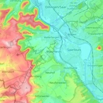
Name: Vaudrevange topographic map, elevation, terrain.
Location: Vaudrevange, Landkreis Saarlouis, Sarre, 66798, Allemagne (49.27980 6.58910 49.34963 6.73264)
Average elevation: 236 m
Minimum elevation: 170 m
Maximum elevation: 386 m
Other topographic maps
Click on a map to view its topography, its elevation and its terrain.
Bous
Allemagne > Sarre > Landkreis Saarlouis
Bous, Landkreis Saarlouis, Sarre, 66359, Allemagne
Average elevation: 217 m
Réhling-Sierbourg
Allemagne > Sarre > Landkreis Saarlouis > Rehlingen-Siersburg > Réhling-Sierbourg
Réhling-Sierbourg, Rehlingen-Siersburg, Landkreis Saarlouis, Sarre, 66780, Allemagne
Average elevation: 208 m
Réhling-Sierbourg
Allemagne > Sarre > Landkreis Saarlouis
Réhling-Sierbourg, Landkreis Saarlouis, Sarre, 66780, Allemagne
Average elevation: 250 m