
Nijeberkoop topographic map
Interactive map
Click on the map to display elevation.
About this map
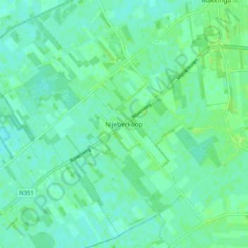
Name: Nijeberkoop topographic map, elevation, terrain.
Location: Nijeberkoop, Ooststellingwerf, Friesland, Niederlande (52.93702 6.14569 52.98056 6.21777)
Average elevation: 4 m
Minimum elevation: 0 m
Maximum elevation: 9 m
Other topographic maps
Click on a map to view its topography, its elevation and its terrain.
Appelscha
Niederlande > Friesland > Ooststellingwerf
Appelscha, Ooststellingwerf, Friesland, Niederlande
Average elevation: 11 m
Ravenswoud
Niederlande > Friesland > Ooststellingwerf
Ravenswoud, Ooststellingwerf, Friesland, Niederlande
Average elevation: 11 m
Donkerbroek
Niederlande > Friesland > Ooststellingwerf
Donkerbroek, Ooststellingwerf, Friesland, Niederlande
Average elevation: 5 m
Langedijke
Niederlande > Friesland > Ooststellingwerf
Langedijke, Ooststellingwerf, Friesland, Niederlande
Average elevation: 8 m