
Auckland topographic map
Click on the map to display elevation.
Auckland
Auckland’s topography is uniquely shaped by its position on a narrow, undulating isthmus between the Waitematā Harbour to the north and the Manukau Harbour to the south, creating a landscape defined by low coastal plains interrupted by abrupt volcanic relief. The city stands atop the Auckland Volcanic Field, a monogenetic field of about 53 volcanic centers composed of scoria cones, tuff rings, explosion craters, and lava flows that rise sharply from surrounding terrain generally lying between 30 and 50 meters above sea level. Prominent cones such as Maungawhau / Mount Eden, reaching 196 meters, and Rangitoto Island at 260 meters—the highest point in the volcanic field—form the main topographic highs, their steep flanks and crater rims contrasting with the gently rolling urban fabric below. Beyond the isthmus, the forested uplands of the Waitākere Ranges to the west and the Hunua Ranges to the southeast rise more substantially, reinforcing a striking relief pattern in which volcanic peaks, drowned river valleys, and deeply indented harbours combine to produce a varied yet generally low-elevation coastal terrain.
About this map
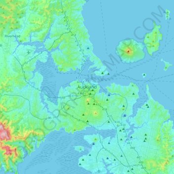
Name: Auckland topographic map, elevation, terrain.
Location: Auckland, Waitematā, Auckland, 1010, New Zealand (-37.01210 174.60318 -36.69210 174.92318)
Average elevation: 32 m
Minimum elevation: -2 m
Maximum elevation: 394 m
Other topographic maps
Click on a map to view its topography, its elevation and its terrain.
Auckland Domain
New Zealand > Auckland > Auckland
During the 2023 Auckland Anniversary Weekend floods, a lake reformed in the lower elevation area of Pukekawa / Auckland Domain that was once a wetland.
Average elevation: 49 m
Auckland
The Auckland Volcanic Field has contributed greatly to the growth and prosperity of the Auckland Region since the area was settled by humans. Initially, the maunga (scoria cones) were occupied and established as pā (fortified settlements) by Māori due to the strategic advantage their elevation provided in…
Average elevation: 44 m
Little Barrier Island
New Zealand > Auckland > Aotea Great Barrier
The island is steeply sloping, and deeply dissected by ravines radiating from a central range that peaks at Mount Hauturu whose altitude is 722 m (2,369 ft). Te Titoki Point is the only area of flat land on the island.
Average elevation: 145 m