
Romaine topographic map
Interactive map
Click on the map to display elevation.
About this map
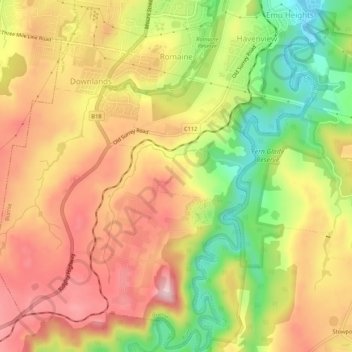
Name: Romaine topographic map, elevation, terrain.
Location: Romaine, Burnie, City of Burnie, Tasmania, Australia (-41.11502 145.87643 -41.07496 145.91387)
Average elevation: 144 m
Minimum elevation: 8 m
Maximum elevation: 253 m
Other topographic maps
Click on a map to view its topography, its elevation and its terrain.
Shorewell Park
Shorewell Park, Burnie, City of Burnie, Tasmania, Australia
Average elevation: 135 m
Emu Heights
Emu Heights, Burnie, City of Burnie, Tasmania, 7320, Australia
Average elevation: 70 m
Upper Burnie
Upper Burnie, Burnie, City of Burnie, Tasmania, 7320, Australia
Average elevation: 111 m
Calder River
Calder River, Burnie, Tasmania, 7320, Australia
Average elevation: 270 m