
Make a donation
Gear up for your next adventure:
As an Amazon Associate, this site earns from qualifying purchases at no extra cost to you.
Pavlodar Region topographic map
Click on the map to display elevation.
Make a donation
Gear up for your next adventure:
As an Amazon Associate, this site earns from qualifying purchases at no extra cost to you.
About this map
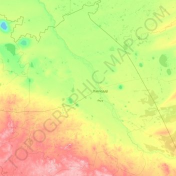
Name: Pavlodar Region topographic map, elevation, terrain.
Location: Pavlodar Region, Kazakhstan (50.01344 73.40578 54.45777 79.34714)
Average elevation: 207 m
Minimum elevation: 26 m
Maximum elevation: 993 m
Make a donation
Gear up for your next adventure:
As an Amazon Associate, this site earns from qualifying purchases at no extra cost to you.
Other topographic maps
Click on a map to view its topography, its elevation and its terrain.
Almaty
Kazakhstan > Bostandıq District
Almaty is still the major commercial, financial, and cultural centre of Kazakhstan, as well as its most populous and most cosmopolitan city. The city is located in the mountainous area of southern Kazakhstan near the border with Kyrgyzstan in the foothills of the Trans-Ili Alatau at an elevation of 700–900 m…
Average elevation: 1,261 m
Border Kazakhstan - Russia
Kazakhstan > East Kazakhstan Region > Katonkaragay District
Average elevation: 2,676 m
Make a donation
Gear up for your next adventure:
As an Amazon Associate, this site earns from qualifying purchases at no extra cost to you.
Qorğaljın
Kazakhstan > Akmola Region > Qorğaljın district
The village is located on the Kazakh Uplands. The average altitude in the village is about 330 meters above sea level. The terrain is a continuous plain with small hills and water areas.
Average elevation: 330 m
Make a donation
Gear up for your next adventure:
As an Amazon Associate, this site earns from qualifying purchases at no extra cost to you.