
Blaine County topographic map
Interactive map
Click on the map to display elevation.
About this map
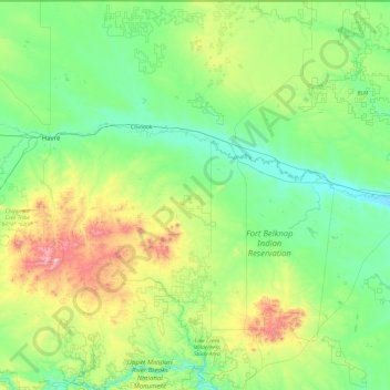
Name: Blaine County topographic map, elevation, terrain.
Location: Blaine County, Montana, Verenigde Staten (47.72263 -109.55335 49.00042 -108.23630)
Average elevation: 930 m
Minimum elevation: 688 m
Maximum elevation: 2,066 m
Other topographic maps
Click on a map to view its topography, its elevation and its terrain.
Yegen
Verenigde Staten > Montana > Yellowstone County
Yegen, Yellowstone County, Montana, 59106, Verenigde Staten
Average elevation: 981 m
Perma
Verenigde Staten > Montana > Sanders County
Perma, Sanders County, Montana, Verenigde Staten
Average elevation: 917 m
Helena
Verenigde Staten > Montana > Lewis and Clark County
Helena, Lewis and Clark County, Montana, Verenigde Staten
Average elevation: 1,296 m
West Yellowstone
Verenigde Staten > Montana > Gallatin County
West Yellowstone, Gallatin County, Montana, Verenigde Staten
Average elevation: 2,034 m
Yellowstone County
Yellowstone County, Montana, Verenigde Staten
Average elevation: 1,067 m
Billings
Verenigde Staten > Montana > Billings
Billings, Yellowstone County, Montana, Verenigde Staten
Average elevation: 1,023 m