Geolocate

Sandy topographic map

Click on the map to display elevation.

About this map

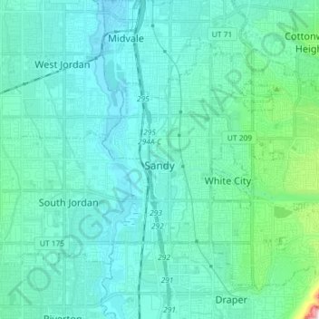
Name: Sandy topographic map, elevation, terrain.

Location: Sandy, Salt Lake County, Utah, United States (40.52766 -111.92162 40.61801 -111.77686)

Average elevation: 1,376 m

Minimum elevation: 1,304 m

Maximum elevation: 1,896 m

Other topographic maps

Click on a map to view its topography, its elevation and its terrain.

Tyler

United States > Utah > Salt Lake County > Murray

Average elevation: 1,334 m

drainage

United States > Utah > Salt Lake County > West Jordan

Average elevation: 1,389 m

Salt Lake City

United States > Utah > Salt Lake County > Salt Lake City

Salt Lake City has an area of 110.4 square miles (286 km2) and an average elevation of 4,327 feet (1,319 m) above sea level. The lowest point within the boundaries of the city is 4,210 feet (1,280 m) near the Jordan River and the Great Salt Lake, and the highest is Grandview Peak, at 9,410 feet (2,868 m).

Average elevation: 1,625 m

Solitude

United States > Utah > Salt Lake County > Solitude

Average elevation: 2,706 m

Gear up for your next adventure:

🖼️Scratch-off Australia Map - Track the regions and peaks you have explored geographically
💡Collapsible Camping Lanterns - Illuminate your base camp or tent for map studying at night
Altimeter Barometer Watches - Outdoor watches with built-in sensors to track altitude changes and weather shifts
Survival Blankets - Emergency thermal blankets
🥾Hiking Boots - Durable hiking boots for trails and rough terrain

As an Amazon Associate, this site earns from qualifying purchases at no extra cost to you.