
Perené topographic map
Interactive map
Click on the map to display elevation.
About this map
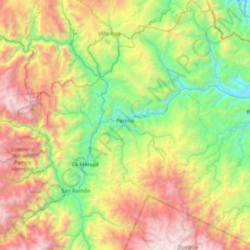
Name: Perené topographic map, elevation, terrain.
Location: Perené, Chanchamayo, Junín, Pérou (-11.26758 -75.27080 -10.65340 -74.86825)
Average elevation: 1,804 m
Minimum elevation: 501 m
Maximum elevation: 4,196 m
Other topographic maps
Click on a map to view its topography, its elevation and its terrain.
Puebl Libre de Azope
Pérou > Junín > Satipo > Puebl Libre de Azope
Puebl Libre de Azope, Satipo, Junín, Pérou
Average elevation: 1,022 m
Santo Domingo del Prado
Pérou > Junín > Nueve de Julio
Santo Domingo del Prado, Nueve de Julio, Concepción, Junín, 12125, Pérou
Average elevation: 3,331 m
Laguna Chacran
Pérou > Junín > Marcapomacocha
Laguna Chacran, JU-508, Marcapomacocha, Yauli, Junín, Pérou
Average elevation: 4,660 m