
Make a donation
Gear up for your next adventure:
As an Amazon Associate, this site earns from qualifying purchases at no extra cost to you.
Coonoor topographic map
Click on the map to display elevation.
Make a donation
Gear up for your next adventure:
As an Amazon Associate, this site earns from qualifying purchases at no extra cost to you.
About this map
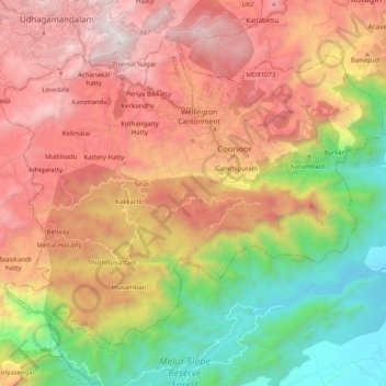
Name: Coonoor topographic map, elevation, terrain.
Location: Coonoor, Nilgiris District, Tamil Nadu, India (11.24489 76.67273 11.40116 76.87533)
Average elevation: 1,460 m
Minimum elevation: 316 m
Maximum elevation: 2,622 m
Make a donation
Gear up for your next adventure:
As an Amazon Associate, this site earns from qualifying purchases at no extra cost to you.
Other topographic maps
Click on a map to view its topography, its elevation and its terrain.
Make a donation
Gear up for your next adventure:
As an Amazon Associate, this site earns from qualifying purchases at no extra cost to you.
Hosur
India > Tamil Nadu > Hosur > Hosur
Hosur experiences a tropical savanna climate (Köppen climate classification) with distinct wet and dry seasons. Due to its high elevation, Hosur usually enjoys salubrious and moderate climate throughout the year, with occasional heat waves. The coolest month is January with an average low temperature of 17.1…
Average elevation: 859 m
Make a donation
Gear up for your next adventure:
As an Amazon Associate, this site earns from qualifying purchases at no extra cost to you.
Edappadi
India > Tamil Nadu > Edappadi > Edappadi
Edappadi has an average elevation of 288 m (945 ft). It is situated at the basin of the hill called 'Soorieya malai' (Mountain of Sun). The mountain does not have any plants due to its rocky and unusual properties. The research done by Periyar University Geologist shows it consist of rare radioactive minerals.…
Average elevation: 224 m
Make a donation
Gear up for your next adventure:
As an Amazon Associate, this site earns from qualifying purchases at no extra cost to you.