
Mukkali topographic map
Interactive map
Click on the map to display elevation.
About this map
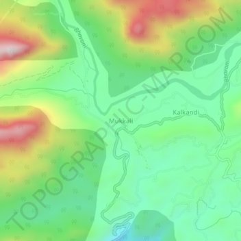
Name: Mukkali topographic map, elevation, terrain.
Location: Mukkali, Mannarkad, Palakkad District, Kerala, India (11.04443 76.52006 11.08443 76.56006)
Average elevation: 618 m
Minimum elevation: 376 m
Maximum elevation: 1,076 m
Other topographic maps
Click on a map to view its topography, its elevation and its terrain.
Kottathara
Kottathara, Mannarkad, Palakkad District, Kerala, India
Average elevation: 549 m
Mannarkkad
Mannarkkad, Mannarkad, Palakkad District, Kerala, 678582, India
Average elevation: 80 m
Silent Valley National Park
Silent Valley National Park, Mannarkad, Palakkad district, Kerala, India
Average elevation: 1,103 m
Kalladikode
Kalladikode, Mannarkad, Palakkad District, Kerala, 678596, India
Average elevation: 101 m