Geolocate

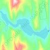
Choteau topographic map

Click on the map to display elevation.

About this map

Name: Choteau topographic map, elevation, terrain.

Location: Choteau, Teton County, Montana, United States (47.80283 -112.19635 47.83038 -112.14936)

Average elevation: 1,173 m

Minimum elevation: 1,153 m

Maximum elevation: 1,207 m

Other topographic maps

Click on a map to view its topography, its elevation and its terrain.

Mount Wright

United States > Montana > Teton County

Average elevation: 2,256 m

Gibson Reservoir

United States > Montana > Teton County

Average elevation: 1,645 m

Ear Mountain

United States > Montana > Teton County

Average elevation: 2,138 m

Gear up for your next adventure:

🧥Packable Rain Jackets - Breathable waterproof layers for unpredictable mountain weather
🧊Insulated Stainless Steel Flasks - Keep water cold for 24 hours in the heat or coffee hot in the cold
⌛Survival Blankets - Emergency thermal blankets
📟Satellite Messengers - Two-way satellite communication to stay in touch beyond the cellular grid
🌬️Windbreaker Jackets - Wind protection jackets

As an Amazon Associate, this site earns from qualifying purchases at no extra cost to you.