
Leshan topographic map
Click on the map to display elevation.
About this map
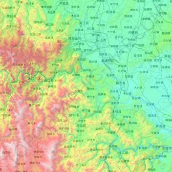
Name: Leshan topographic map, elevation, terrain.
Location: Leshan, Sichuan, China (28.42251 102.90475 29.93141 104.24979)
Average elevation: 1,158 m
Minimum elevation: 260 m
Maximum elevation: 4,128 m
Other topographic maps
Click on a map to view its topography, its elevation and its terrain.
Mount Gongga
China > Sichuan > Luding County
Mount Gongga (simplified Chinese: 贡嘎山; traditional Chinese: 貢嘎山; pinyin: Gònggá Shān), also known as Minya Konka (Khams Tibetan pinyin: Mi'nyâg Gong'ga Riwo) and colloquially as "The King of Sichuan Mountains", is the highest mountain in Sichuan province, China. It has an elevation of 7,556 m…
Average elevation: 6,496 m