
Liège topographic map
Interactive map
Click on the map to display elevation.
About this map
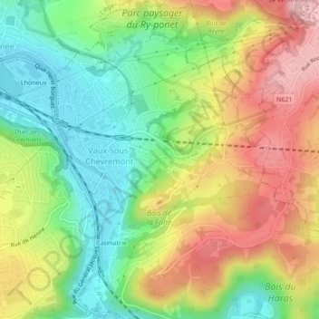
Name: Liège topographic map, elevation, terrain.
Location: Liège, Wallonia, 4051, Belgium (50.58811 5.62447 50.61490 5.65547)
Average elevation: 149 m
Minimum elevation: 66 m
Maximum elevation: 250 m
Other topographic maps
Click on a map to view its topography, its elevation and its terrain.
Haute-Bodeux
Haute-Bodeux, Trois-Ponts, Verviers, Liège, Wallonia, 4980, Belgium
Average elevation: 423 m
Bütgenbach
Bütgenbach, Verviers, Liège, Wallonia, 4750, Belgium
Average elevation: 575 m
Francorchamps
Belgium > Liège > Verviers > Francorchamps
Francorchamps, Stavelot, Verviers, Liège, Wallonia, 4970, Belgium
Average elevation: 482 m