

Perth topographic map
Click on the map to display elevation.
Perth
Perth, the capital of Western Australia, is situated on the Swan Coastal Plain, a flat expanse of sandy soil nestled between the Indian Ocean to the west and the Darling Scarp to the east. The Darling Scarp, also known as the Darling Range, is a low escarpment that extends north–south, marking a distinct geological boundary where the ancient Yilgarn Craton meets younger geological formations. This escarpment rises abruptly from the coastal plain, creating a notable contrast in elevation and offering a backdrop of rolling hills to the city's skyline. The Swan River meanders through Perth, providing a central feature around which the city has developed. Beneath the northern suburbs lies the Gnangara Mound, a significant sandy aquifer that serves as a crucial source of fresh water for the region. Offshore, the Perth Canyon—a massive submarine canyon comparable in size to the Grand Canyon—traverses the continental shelf, plunging to depths of up to 4,000 meters (13,123 feet) and highlighting the dramatic underwater topography adjacent to the coastal landscape. Collectively, these features define Perth's diverse terrain, encompassing coastal plains, riverine landscapes, escarpments, and significant geological formations both on land and beneath the sea.
About this map
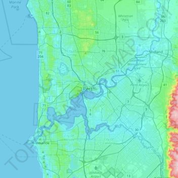
Name: Perth topographic map, elevation, terrain.
Location: Perth, Western Australia, 6000, Australia (-32.11590 115.70058 -31.79590 116.02058)
Average elevation: 26 m
Minimum elevation: -2 m
Maximum elevation: 288 m
Western Australia trails, hiking, mountain biking, running and outdoor activities
Other topographic maps
Click on a map to view its topography, its elevation and its terrain.































Henley Brook
Henley Brook is situated on the flood plains of the Swan River, with regularly occurring seasonal floods. Two ephemeral streams from the river - Henley Brook and St. Leonard's Creek - traverse the suburb. Henley Brook is in the north-east near Brockman Street, while St Leonards Creek traverses the centre of…
Average elevation: 28 m