
Metcalfe County topographic map
Interactive map
Click on the map to display elevation.
About this map
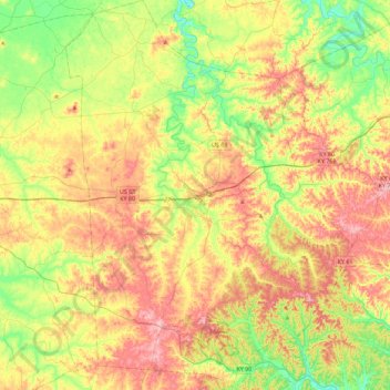
Name: Metcalfe County topographic map, elevation, terrain.
Location: Metcalfe County, Kentucky, United States of America (36.81869 -85.77706 37.18220 -85.44180)
Average elevation: 251 m
Minimum elevation: 165 m
Maximum elevation: 354 m
Other topographic maps
Click on a map to view its topography, its elevation and its terrain.
High Plains
United States of America > Kentucky > High Plains
High Plains, Breckinridge County, Kentucky, 40115, United States of America
Average elevation: 228 m
Covington
United States of America > Kentucky > Covington
Covington, Kenton County, Kentucky, United States of America
Average elevation: 215 m
Pineville
United States of America > Kentucky > Pineville
Pineville, Bell County, Kentucky, United States of America
Average elevation: 426 m
Ready
United States of America > Kentucky > Ready
Ready, Grayson County, Kentucky, United States of America
Average elevation: 206 m
Monroe County
United States of America > Kentucky
Monroe County, Kentucky, United States of America
Average elevation: 250 m
Cumberland County
United States of America > Kentucky
Cumberland County, Kentucky, United States of America
Average elevation: 237 m
Pomp
United States of America > Kentucky > Pomp
Pomp, Morgan County, Kentucky, 41472, United States of America
Average elevation: 282 m
Lawrenceburg
United States of America > Kentucky > Lawrenceburg > Lawrenceburg
Lawrenceburg, Anderson County, Kentucky, 40342, United States of America
Average elevation: 244 m
Millard
United States of America > Kentucky > Millard
Nelse, Millard, Pike County, Kentucky, 41562, United States of America
Average elevation: 315 m