
Macon County topographic map
Click on the map to display elevation.
Macon County
Cullasaja Falls is a waterfall in Southwestern North Carolina east of Franklin. The waterfall is located on the Cullasaja River in the Nantahala National Forest and is part of the Mountain Waters Scenic Byway. Cullasaja comes from a Cherokee word meaning "honey locust place." The falls is the last major waterfall on the Cullasaja River. The falls is a long cascade over the course of 0.2 miles (300 m). The height of the falls is given as 200 ft (61 m) in Kevin Adams' book, North Carolina Waterfalls and 250 ft (76 m) by NCWaterfalls.com. Google Earth gives a height (based on the elevation of the water at the top of the falls and the elevation of the plunge pool at the bottom of the falls) of 137 ft (42 m).
About this map
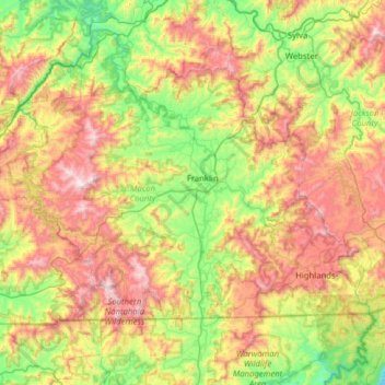
Name: Macon County topographic map, elevation, terrain.
Location: Macon County, North Carolina, United States (34.99331 -83.73818 35.33098 -83.10840)
Average elevation: 904 m
Minimum elevation: 418 m
Maximum elevation: 1,650 m
Other topographic maps
Click on a map to view its topography, its elevation and its terrain.
Atlantic Coastal Plain
United States > North Carolina > Cumberland County > Fayetteville
The province's average elevation is less than 900 meters above sea level and extends some 50 to 100 kilometers inland from the ocean. The coastal plain is normally wet, including many rivers, marsh, and swampland. It is composed primarily of sedimentary rock and unlithified sediments and is primarily used for…
Average elevation: 51 m
Mount Pleasant Water Lagoon
United States > North Carolina > Cabarrus County > Mount Pleasant
Average elevation: 203 m
Five Points Park
United States > North Carolina > Guilford County > High Point
Average elevation: 264 m
Green Mill Run
United States > North Carolina > Pitt County > Greenville > Greenbrier
Average elevation: 21 m
Sharonbrook
United States > North Carolina > Mecklenburg County > Charlotte > Sharonbrook
Average elevation: 187 m
Murry Hill Park
United States > North Carolina > Buncombe County > Asheville > River Arts District
Average elevation: 639 m
Redwood Village
United States > North Carolina > Buncombe County > Asheville > Redwood Village
Average elevation: 657 m