Geolocate

Makaha topographic map

Click on the map to display elevation.

About this map

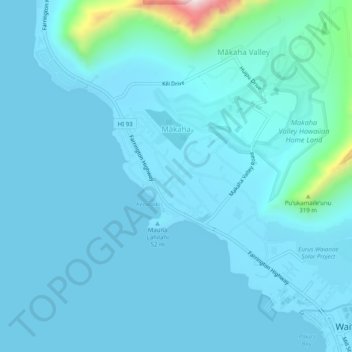
Name: Makaha topographic map, elevation, terrain.

Location: Makaha, Honolulu County, Hawaii, United States (21.44334 -158.24124 21.48992 -158.19684)

Average elevation: 41 m

Minimum elevation: 0 m

Maximum elevation: 663 m

Gear up for your next adventure:

🧥Softshell Jackets - Flexible outdoor jackets
🧼Biodegradable Outdoor Soap - Clean gear and yourself without harming the local ecosystem
🔌Fast Charging Adapters - Quickly top up all your gear before heading back into the field
🧺Fast-Dry Microfiber Towels - Large towels that pack down to the size of an orange
🎒Hiking Backpacks - Backpacks designed for hiking and trekking

As an Amazon Associate, this site earns from qualifying purchases at no extra cost to you.