
Make a donation
Gear up for your next adventure:
As an Amazon Associate, this site earns from qualifying purchases at no extra cost to you.
Bahia topographic map
Click on the map to display elevation.
Make a donation
Gear up for your next adventure:
As an Amazon Associate, this site earns from qualifying purchases at no extra cost to you.
About this map
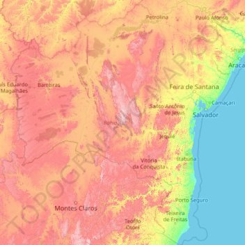
Name: Bahia topographic map, elevation, terrain.
Location: Bahia, Northeast Region, Brazil (-18.39345 -46.57728 -8.53229 -37.17715)
Average elevation: 475 m
Minimum elevation: 0 m
Maximum elevation: 1,878 m
Make a donation
Gear up for your next adventure:
As an Amazon Associate, this site earns from qualifying purchases at no extra cost to you.
Other topographic maps
Click on a map to view its topography, its elevation and its terrain.
São Paulo
Brazil > São Paulo > Região Metropolitana de São Paulo > São Paulo
São Paulo is in Southeastern Brazil, in southeastern São Paulo State, approximately halfway between Curitiba and Rio de Janeiro. The city is on a plateau placed beyond the Serra do Mar (Portuguese for "Sea Range" or "Coastal Range"), itself a component of the vast region known as the Brazilian Highlands,…
Average elevation: 785 m
Ilha Sumítica
Brazil > São Paulo > Região Metropolitana do Vale do Paraíba e Litoral Norte > Ilhabela
Average elevation: 1 m
Make a donation
Gear up for your next adventure:
As an Amazon Associate, this site earns from qualifying purchases at no extra cost to you.
Sugarloaf
Brazil > Rio de Janeiro > Região Metropolitana do Rio de Janeiro > Rio de Janeiro
Average elevation: 17 m
Brasília
Brazil > Federal District > Região Integrada de Desenvolvimento do Distrito Federal e Entorno
The city sits at an elevation of 1,000 metres (3,300 ft) and more, high on the Brazilian Highlands in the country's center-western region. Paranoá Lake, a large artificial lake, was built to increase the amount of water available and to maintain the region's humidity. It has a marina, and hosts wakeboarders…
Average elevation: 1,084 m
Make a donation
Gear up for your next adventure:
As an Amazon Associate, this site earns from qualifying purchases at no extra cost to you.
Brasília
Brazil > Federal District > Região Integrada de Desenvolvimento do Distrito Federal e Entorno
The city sits at an elevation of 1,000 metres (3,300 ft) and more, high on the Brazilian Highlands in the country's center-western region. Paranoá Lake, a large artificial lake, was built to increase the amount of water available and to maintain the region's humidity. It has a marina, and hosts wakeboarders…
Average elevation: 1,084 m
Praça Tenente Roberto Osaki
Brazil > São Paulo > Região Metropolitana de São Paulo > Osasco
Average elevation: 731 m
Make a donation
Gear up for your next adventure:
As an Amazon Associate, this site earns from qualifying purchases at no extra cost to you.
Ilha Sumítica
Brazil > São Paulo > Região Metropolitana do Vale do Paraíba e Litoral Norte > Ilhabela
Average elevation: 1 m
Make a donation
Gear up for your next adventure:
As an Amazon Associate, this site earns from qualifying purchases at no extra cost to you.
Kobayat Líbano
Brazil > São Paulo > Região Metropolitana de Piracicaba > Piracicaba
Average elevation: 521 m
Chapada Diamantina
The Chapada Diamantina lies at the center of Bahia State and forms the northern part of the Espinhaço Mountain Range. The region is approximately 38,000 km2 (15,000 sq mi) in area and encompasses 58 municipalities. Technically, this region is considered a part of the caatinga biome, and contains some of its…
Average elevation: 1,390 m
Amazon River
During what many archaeologists called the formative stage, Amazonian societies were deeply involved in the emergence of South America's highland agrarian systems. The trade with Andean civilizations in the terrains of the headwaters in the Andes formed an essential contribution to the social and religious…
Average elevation: 9 m
Make a donation
Gear up for your next adventure:
As an Amazon Associate, this site earns from qualifying purchases at no extra cost to you.
Wei-Assipu-tepui
Wei-Assipu-tepui has a maximum elevation of around 2,400 metres (7,870 ft). Its summit plateau is highly dissected and generally inclined south-southwest (towards the Brazilian side). The rocky summit is partially forested, with flowering plants of the genus Bonnetia featuring prominently. It also hosts a…
Average elevation: 1,760 m
Praia do Forte
Brazil > Bahia > Região Metropolitana de Salvador > Mata de São João
Average elevation: 5 m
Make a donation
Gear up for your next adventure:
As an Amazon Associate, this site earns from qualifying purchases at no extra cost to you.
Amazon River
During what many archaeologists called the formative stage, Amazonian societies were deeply involved in the emergence of South America's highland agrarian systems. The trade with Andean civilizations in the terrains of the headwaters in the Andes formed an essential contribution to the social and religious…
Average elevation: 19 m
Make a donation
Gear up for your next adventure:
As an Amazon Associate, this site earns from qualifying purchases at no extra cost to you.
Make a donation
Gear up for your next adventure:
As an Amazon Associate, this site earns from qualifying purchases at no extra cost to you.
Chapada Diamantina
The Chapada Diamantina lies at the center of Bahia State and forms the northern part of the Espinhaço Mountain Range. The region is approximately 38,000 km2 (15,000 sq mi) in area and encompasses 58 municipalities. Technically, this region is considered a part of the caatinga biome, and contains some of its…
Average elevation: 1,390 m
Pedra do Baú
Brazil > São Paulo > Região Metropolitana do Vale do Paraíba e Litoral Norte > São Bento do Sapucaí
At its highest point, the elevation is 1,950 metres (6,400 ft).
Average elevation: 1,502 m
Vale das Pedrinhas
Brazil > Rio de Janeiro > Região Metropolitana do Rio de Janeiro > Guapimirim
Average elevation: 8 m
Make a donation
Gear up for your next adventure:
As an Amazon Associate, this site earns from qualifying purchases at no extra cost to you.
Make a donation
Gear up for your next adventure:
As an Amazon Associate, this site earns from qualifying purchases at no extra cost to you.
Make a donation
Gear up for your next adventure:
As an Amazon Associate, this site earns from qualifying purchases at no extra cost to you.
Serra da Borborema
Brazil > Paraíba > Região Metropolitana de Patos > Cacimbas
Average elevation: 573 m
Amazon River
During what many archaeologists called the formative stage, Amazonian societies were deeply involved in the emergence of South America's highland agrarian systems. The trade with Andean civilizations in the terrains of the headwaters in the Andes formed an essential contribution to the social and religious…
Average elevation: 11 m
Bosque Gutierrez
Brazil > Paraná > Região Metropolitana de Curitiba > Curitiba
Average elevation: 940 m
Make a donation
Gear up for your next adventure:
As an Amazon Associate, this site earns from qualifying purchases at no extra cost to you.
Make a donation
Gear up for your next adventure:
As an Amazon Associate, this site earns from qualifying purchases at no extra cost to you.
Praça Bartolomeu de Messina
Brazil > São Paulo > Região Metropolitana de São Paulo > São Paulo
Average elevation: 790 m
Make a donation
Gear up for your next adventure:
As an Amazon Associate, this site earns from qualifying purchases at no extra cost to you.
Amazon River
During what many archaeologists called the formative stage, Amazonian societies were deeply involved in the emergence of South America's highland agrarian systems. The trade with Andean civilizations in the terrains of the headwaters in the Andes formed an essential contribution to the social and religious…
Average elevation: 10 m
Itaipu Dam
Brazil > Paraná > Foz do Iguaçu
325 metres (1,066 ft), entire dam including the 100 metres (330 ft) high Power Line 4 Pylons atop the Barrage 260 metres (850 ft), dam + the foundation inside water until the river floor 247 metres (810 ft), 196 metres (643 ft) high of roof reinforcement concrete dam + Cranes atop the Barrage 225 metres (738…
Average elevation: 192 m
Corcovado
Brazil > Rio de Janeiro > Região Metropolitana do Rio de Janeiro > Rio de Janeiro
Average elevation: 221 m
Make a donation
Gear up for your next adventure:
As an Amazon Associate, this site earns from qualifying purchases at no extra cost to you.
Morro da Babilônia
Brazil > Rio de Janeiro > Região Metropolitana do Rio de Janeiro > Rio de Janeiro
Average elevation: 29 m
Make a donation
Gear up for your next adventure:
As an Amazon Associate, this site earns from qualifying purchases at no extra cost to you.
Chapada Diamantina
The Chapada Diamantina lies at the center of Bahia State and forms the northern part of the Espinhaço Mountain Range. The region is approximately 38,000 km2 (15,000 sq mi) in area and encompasses 58 municipalities. Technically, this region is considered a part of the caatinga biome, and contains some of its…
Average elevation: 1,390 m
Make a donation
Gear up for your next adventure:
As an Amazon Associate, this site earns from qualifying purchases at no extra cost to you.
Lagoa dos Ingleses
Brazil > Minas Gerais > Região Metropolitana de Belo Horizonte > Nova Lima
Average elevation: 1,335 m
Pico da Neblina
Brazil > Amazonas > Santa Isabel do Rio Negro
For 39 years, based on an uncontested measurement performed in 1965 by topographer José Ambrósio de Miranda Pombo, using a theodolite, the elevation of Pico da Neblina was thought to be 3,014 metres (9,888 ft), but a much more accurate measurement performed in 2004 with state-of-the-art GPS equipment by…
Average elevation: 2,178 m
Make a donation
Gear up for your next adventure:
As an Amazon Associate, this site earns from qualifying purchases at no extra cost to you.
Amazon River
During what many archaeologists called the formative stage, Amazonian societies were deeply involved in the emergence of South America's highland agrarian systems. The trade with Andean civilizations in the terrains of the headwaters in the Andes formed an essential contribution to the social and religious…
Average elevation: 11 m
Make a donation
Gear up for your next adventure:
As an Amazon Associate, this site earns from qualifying purchases at no extra cost to you.
Make a donation
Gear up for your next adventure:
As an Amazon Associate, this site earns from qualifying purchases at no extra cost to you.
Costa do Sauípe
Brazil > Bahia > Região Metropolitana de Salvador > Mata de São João
Average elevation: 10 m
Quinta da Boa Vista
Brazil > Rio de Janeiro > Região Metropolitana do Rio de Janeiro > Rio de Janeiro
Average elevation: 19 m
Make a donation
Gear up for your next adventure:
As an Amazon Associate, this site earns from qualifying purchases at no extra cost to you.
Estrada Carlos Dreyer
Brazil > Rio Grande do Sul > Metropolitan Region of Porto Alegre > Igrejinha
Average elevation: 622 m
Make a donation
Gear up for your next adventure:
As an Amazon Associate, this site earns from qualifying purchases at no extra cost to you.
Morro do Pico Agudo
Brazil > São Paulo > Região Metropolitana do Vale do Paraíba e Litoral Norte > Paraibuna
Average elevation: 1,056 m
Make a donation
Gear up for your next adventure:
As an Amazon Associate, this site earns from qualifying purchases at no extra cost to you.
Praça Farias Neves
Brazil > Pernambuco > Região Metropolitana do Recife > Recife
Average elevation: 22 m
Curitiba
Brazil > Paraná > Região Metropolitana de Curitiba
The city covers 432.17 km2 (166.86 sq mi) on the First Plateau of Paraná. Curitiba has a topography of smooth, rounded hills, giving it a relatively regular shape. The city has an average altitude of 934.6 m (3,066 ft) above sea level. The highest point is to the north at 1,021 m (3,350 ft), and with lower…
Average elevation: 931 m
Make a donation
Gear up for your next adventure:
As an Amazon Associate, this site earns from qualifying purchases at no extra cost to you.
Make a donation
Gear up for your next adventure:
As an Amazon Associate, this site earns from qualifying purchases at no extra cost to you.