
Make a donation
Gear up for your next adventure:
As an Amazon Associate, this site earns from qualifying purchases at no extra cost to you.
Short Pump topographic map
Click on the map to display elevation.
Make a donation
Gear up for your next adventure:
As an Amazon Associate, this site earns from qualifying purchases at no extra cost to you.
About this map
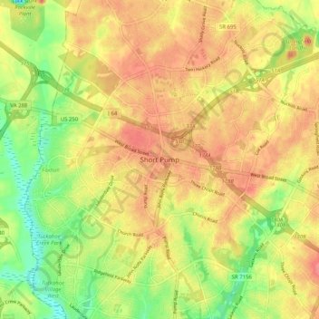
Name: Short Pump topographic map, elevation, terrain.
Location: Short Pump, Henrico County, Virginia, 23233, United States (37.61061 -77.65195 37.69061 -77.57195)
Average elevation: 72 m
Minimum elevation: 32 m
Maximum elevation: 101 m
Make a donation
Gear up for your next adventure:
As an Amazon Associate, this site earns from qualifying purchases at no extra cost to you.
Other topographic maps
Click on a map to view its topography, its elevation and its terrain.
Canterbury Lake
United States > Virginia > Henrico County > Tuckahoe > Canterbury
Average elevation: 58 m
Canterbury Dam
United States > Virginia > Henrico County > Tuckahoe > Canterbury
Average elevation: 57 m
Make a donation
Gear up for your next adventure:
As an Amazon Associate, this site earns from qualifying purchases at no extra cost to you.