
Shaftesbury topographic map
Interactive map
Click on the map to display elevation.
Shaftesbury
The English name was recorded in the Domesday Book of 1086 as Sceptesberie, and the use of "Shaston" (/ˈʃæstən/) was recorded in 1831 in Samuel Lewis's A Topographical Dictionary of England and in 1840 in The parliamentary gazetteer of England and Wales.
About this map
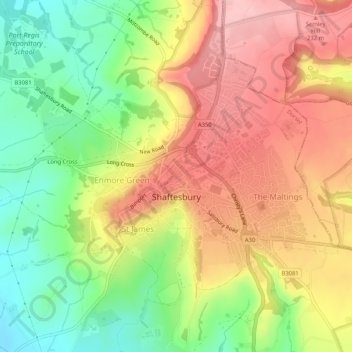
Name: Shaftesbury topographic map, elevation, terrain.
Location: Shaftesbury, Dorset, England, United Kingdom (50.99551 -2.22374 51.01951 -2.17173)
Average elevation: 167 m
Minimum elevation: 81 m
Maximum elevation: 248 m
Other topographic maps
Click on a map to view its topography, its elevation and its terrain.