
Darjeeling topographic map
Interactive map
Click on the map to display elevation.
About this map
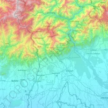
Name: Darjeeling topographic map, elevation, terrain.
Location: Darjeeling, Westbengalen, Indien (26.44839 87.98729 27.22120 88.51264)
Average elevation: 728 m
Minimum elevation: 70 m
Maximum elevation: 3,595 m
Other topographic maps
Click on a map to view its topography, its elevation and its terrain.
Mayapur
Indien > Westbengalen > Nabadwip
Mayapur, Nabadwip, Nadia District, Westbengalen, 741313, Indien
Average elevation: 10 m
Murshidabad
Indien > Westbengalen > Murshidabad Jiaganj
Murshidabad, Murshidabad Jiaganj, Murshidabad District, Westbengalen, 742149, Indien
Average elevation: 20 m
Darjeeling
Indien > Westbengalen > Darjeeling Pulbazar
Darjeeling, Darjeeling Pulbazar, Darjeeling District, Westbengalen, 734101, Indien
Average elevation: 1,324 m
Bagdogra
Indien > Westbengalen > Naxalbari block
Bagdogra, Naxalbari block, Darjeeling District, Westbengalen, 734013, Indien
Average elevation: 136 m
Bangaon
Indien > Westbengalen > Bongaon > Bangaon
Bangaon, Bongaon, North 24 Parganas, Westbengalen, 743235, Indien
Average elevation: 7 m
Kalkutta
Indien > Westbengalen > Kalkutta
Kalkutta, Kolkata, Westbengalen, 700069, Indien
Average elevation: 5 m