
Dounreay topographic map
Interactive map
Click on the map to display elevation.
About this map
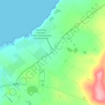
Name: Dounreay topographic map, elevation, terrain.
Location: Dounreay, Caithness, Scotland, KW14 7TZ, United Kingdom (58.55331 -3.75372 58.59331 -3.71372)
Average elevation: 36 m
Minimum elevation: 0 m
Maximum elevation: 133 m
Other topographic maps
Click on a map to view its topography, its elevation and its terrain.
Thurso
United Kingdom > Scotland > Caithness
Thurso, Caithness, Scotland, United Kingdom
Average elevation: 25 m
Thrumster
United Kingdom > Scotland > Caithness > Thrumster
Thrumster, Caithness, Scotland, KW1 5TQ, United Kingdom
Average elevation: 61 m