
Highland Beach topographic map
Interactive map
Click on the map to display elevation.
About this map
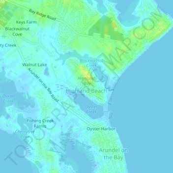
Name: Highland Beach topographic map, elevation, terrain.
Location: Highland Beach, Anne Arundel County, Maryland, United States (38.92832 -76.46978 38.93401 -76.46271)
Average elevation: 3 m
Minimum elevation: -2 m
Maximum elevation: 16 m
Other topographic maps
Click on a map to view its topography, its elevation and its terrain.
Warthen Knolls
United States > Maryland > Anne Arundel County
Warthen Knolls, Anne Arundel County, Maryland, 20776, United States
Average elevation: 37 m
High Point
United States > Maryland > Anne Arundel County > Pasadena
High Point, Pasadena, Anne Arundel County, Maryland, 21122, United States
Average elevation: 12 m
Springwood
United States > Maryland > Anne Arundel County > Jessup
Springwood, Jessup, Anne Arundel County, Maryland, 20794, United States
Average elevation: 63 m
Benfield
United States > Maryland > Anne Arundel County > Glen Burnie
Benfield, Glen Burnie, Anne Arundel County, Maryland, 21108, United States
Average elevation: 25 m
Leeds
United States > Maryland > Anne Arundel County
Leeds, Anne Arundel County, Maryland, 21077, United States
Average elevation: 47 m
Boones Mobile Estates
United States > Maryland > Anne Arundel County
Boones Mobile Estates, Anne Arundel County, Maryland, 20711, United States
Average elevation: 30 m
Crofton
United States > Maryland > Anne Arundel County
Crofton, Anne Arundel County, Maryland, 21114, United States
Average elevation: 35 m
Franklin Manor Beach
United States > Maryland > Anne Arundel County
Franklin Manor Beach, Anne Arundel County, Maryland, 20733, United States
Average elevation: 1 m
Woodcrest
United States > Maryland > Anne Arundel County > Ferndale
Woodcrest, Ferndale, Anne Arundel County, Maryland, 21062, United States
Average elevation: 28 m
Riva
United States > Maryland > Anne Arundel County
Riva, Anne Arundel County, Maryland, 21041, United States
Average elevation: 11 m
Pasadena Beach
United States > Maryland > Anne Arundel County
Pasadena Beach, Anne Arundel County, Maryland, United States
Average elevation: 4 m
Crownsville
United States > Maryland > Anne Arundel County > Crownsville
Crownsville, Anne Arundel County, Maryland, 21140, United States
Average elevation: 30 m
Green Haven
United States > Maryland > Anne Arundel County > Pasadena
Green Haven, Pasadena, Anne Arundel County, Maryland, 21122, United States
Average elevation: 15 m
Deale
United States > Maryland > Anne Arundel County > Deale
Deale, Anne Arundel County, Maryland, United States
Average elevation: 5 m
Galesville
United States > Maryland > Anne Arundel County > Galesville
Galesville, Anne Arundel County, Maryland, United States
Average elevation: 4 m
Powhatan Village
United States > Maryland > Anne Arundel County > Pasadena
Powhatan Village, Pasadena, Anne Arundel County, Maryland, 21060, United States
Average elevation: 19 m
Lower Magothy Beach
United States > Maryland > Anne Arundel County > Severna Park
Lower Magothy Beach, Severna Park, Anne Arundel County, Maryland, 21122, United States
Average elevation: 9 m
Cranberry Woods
United States > Maryland > Anne Arundel County > Crownsville
Cranberry Woods, Crownsville, Anne Arundel County, Maryland, 21140, United States
Average elevation: 32 m
Edgewater Beach
United States > Maryland > Anne Arundel County > Riva
Edgewater Beach, Riva, Anne Arundel County, Maryland, 21041, United States
Average elevation: 9 m
Fort Meade
United States > Maryland > Anne Arundel County > Fort Meade
Fort Meade, Anne Arundel County, Maryland, 20755, United States
Average elevation: 53 m
Churchton
United States > Maryland > Anne Arundel County
Churchton, Anne Arundel County, Maryland, 20733, United States
Average elevation: 2 m
Edgewater
United States > Maryland > Anne Arundel County
Edgewater, Anne Arundel County, Maryland, 21037, United States
Average elevation: 7 m
Jacobsville
United States > Maryland > Anne Arundel County > Pasadena
Jacobsville, Pasadena, Anne Arundel County, Maryland, 21122, United States
Average elevation: 18 m
Avalon Shores
United States > Maryland > Anne Arundel County > Shady Side
Avalon Shores, Shady Side, Anne Arundel County, Maryland, 20764, United States
Average elevation: 1 m
Odenton
United States > Maryland > Anne Arundel County > Odenton
Odenton, Anne Arundel County, Maryland, United States
Average elevation: 41 m
Gambrills
United States > Maryland > Anne Arundel County > Gambrills
Gambrills, Anne Arundel County, Maryland, United States
Average elevation: 37 m
Venice Beach
United States > Maryland > Anne Arundel County > Arundel on the Bay > Venice Beach
Venice Beach, Highland Beach, Arundel on the Bay, Anne Arundel County, Maryland, 21403, United States
Average elevation: 2 m
Annapolis
United States > Maryland > Anne Arundel County > Annapolis
Annapolis, Anne Arundel County, Maryland, 21411, United States
Average elevation: 13 m
Londontown Terrace
United States > Maryland > Anne Arundel County > Londontown Terrace
Londontown Terrace, Anne Arundel County, Maryland, 21037, United States
Average elevation: 4 m
Annapolis
United States > Maryland > Anne Arundel County
Annapolis, Anne Arundel County, Maryland, United States
Average elevation: 8 m
Crofton
United States > Maryland > Anne Arundel County > Crofton
Crofton, Anne Arundel County, Maryland, 21114, United States
Average elevation: 35 m
The Provinces
United States > Maryland > Anne Arundel County > Severn
The Provinces, Severn, Anne Arundel County, Maryland, 21144, United States
Average elevation: 57 m