
Huergo topographic map
Interactive map
Click on the map to display elevation.
About this map
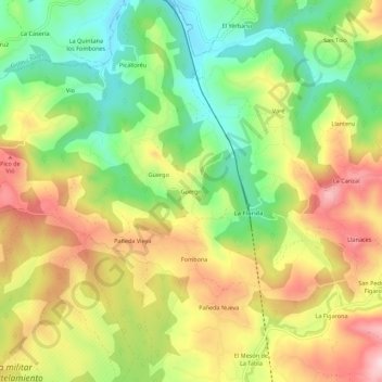
Name: Huergo topographic map, elevation, terrain.
Location: Huergo, Siero, Asturias, 33180, España (43.41624 -5.73820 43.45624 -5.69820)
Average elevation: 196 m
Minimum elevation: 69 m
Maximum elevation: 338 m
Other topographic maps
Click on a map to view its topography, its elevation and its terrain.
Pola de Siero
Pola de Siero, Siero, Asturias, 33510, España
Average elevation: 270 m
Negales
España > Asturias > Siero > Pola de Siero
Negales, Pola de Siero, Siero, Asturias, 33519, España
Average elevation: 271 m