Crooked River topographic map
Click on the map to display elevation.
Crooked River
The Lower Crooked Wild and Scenic River flows through 2,300 acres (930 ha) of public lands overseen by the Bureau of Land Management and 220 acres (89 ha) overseen by the Bureau of Reclamation. The Chimney Rock segment below Bowman Dam has nine developed campsites, seven of which are meant for single-family camping, and two that are multi-family or group sites. All are fee sites; all have toilets; only one, Chimney Rock, has drinking water. Opposite the Chimney Rock Campground is the trailhead for Chimney Rock Trail, which winds up a side canyon for 1.3 miles (2.1 km) to higher-elevation views of the main canyon and the Cascade Range. The BLM also oversees two day-use sites along this stretch of the river. All of these installations are connected by Oregon Route 27, which follows the river between the dam and Prineville.
About this map
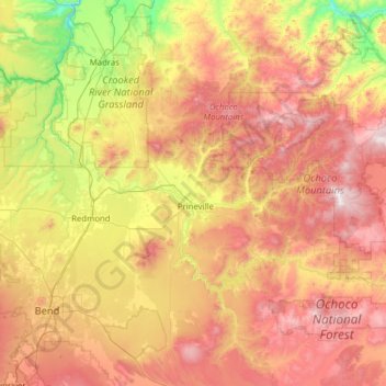
Name: Crooked River topographic map, elevation, terrain.
Location: Crooked River, Oregon, United States (44.08457 -121.30230 44.57367 -120.05273)
Average elevation: 1,131 m
Minimum elevation: 420 m
Maximum elevation: 2,094 m
Other topographic maps
Click on a map to view its topography, its elevation and its terrain.


Mount Scott
United States > Oregon > Klamath County
There is one trail to the summit of Mount Scott. Starting on Rim Drive, the trail is about 2.5 miles (4.0 km) long. It has many switchbacks, and ends at the fire lookout tower on the summit. The trailhead is at an elevation of 7,683 feet (2,342 m), and the trail climbs approximately 1,479 feet (451 m) to the…
Average elevation: 2,295 m